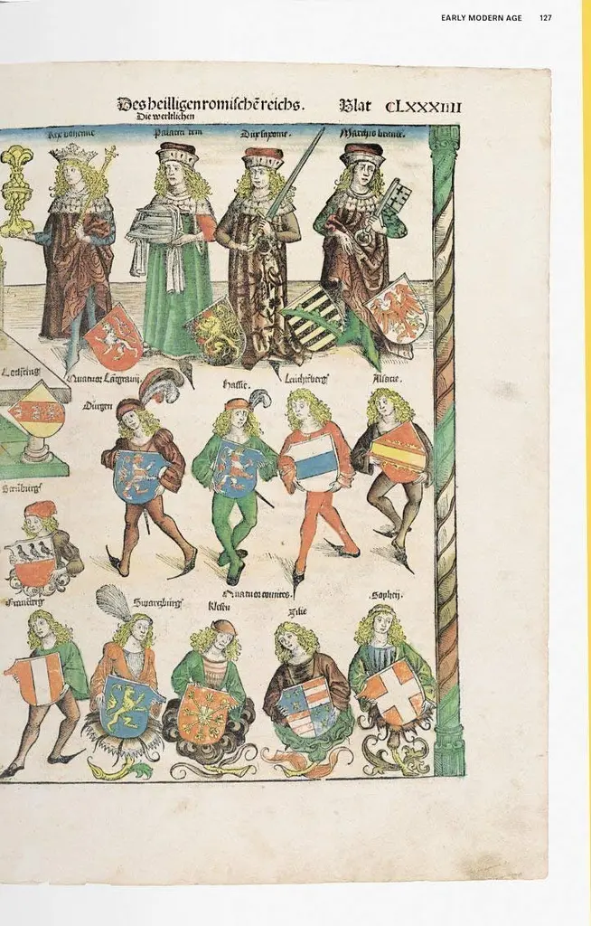
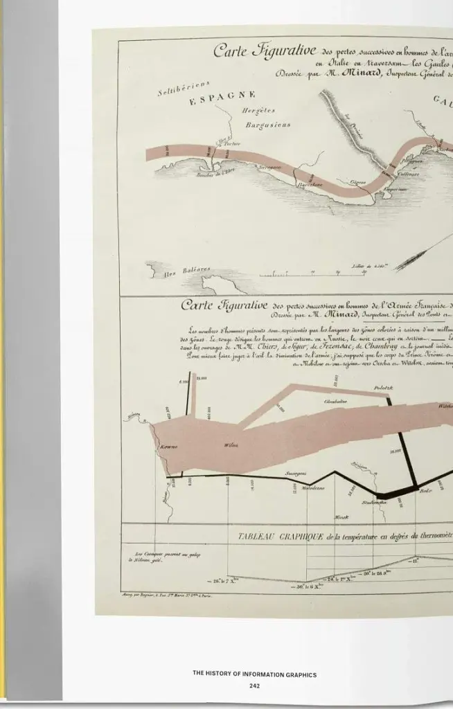
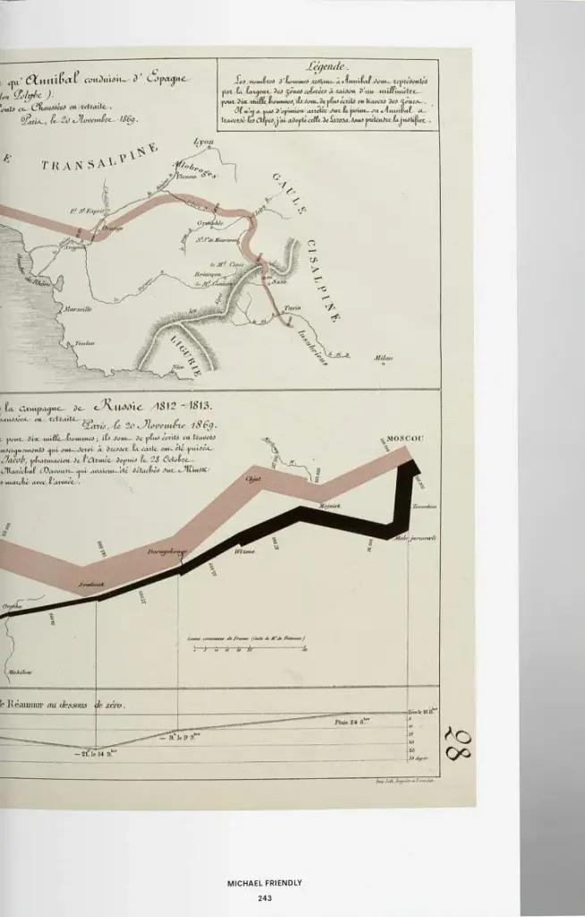
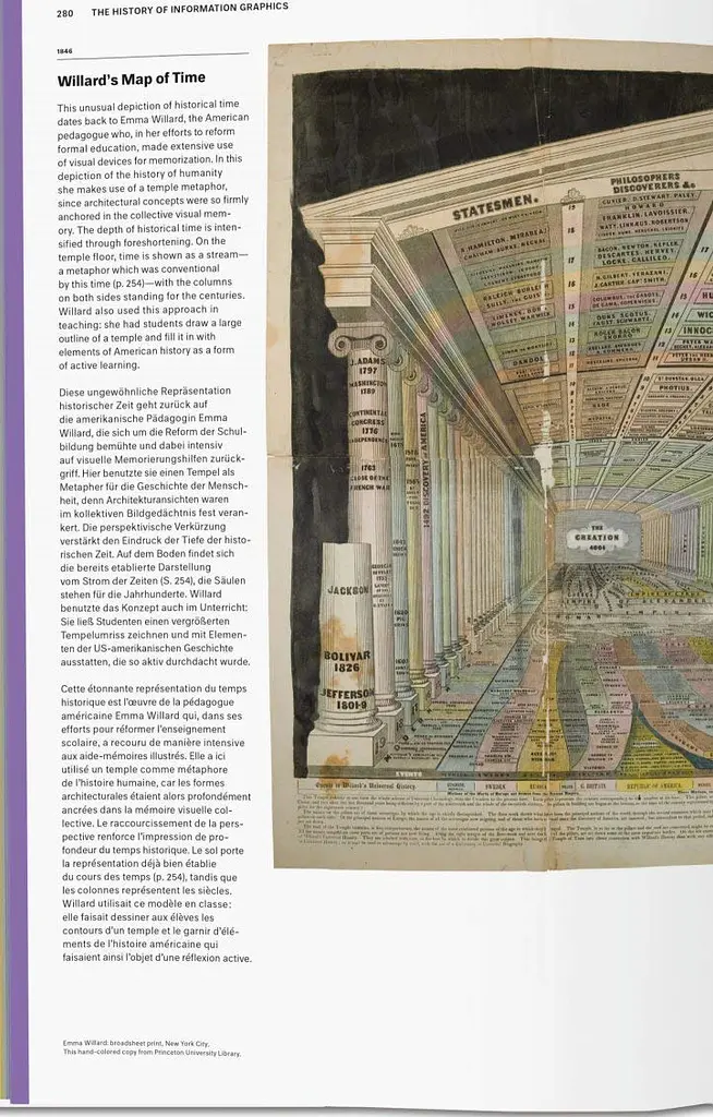


History of Infographics
Код товару: RE_1805561
Акція
До кінця акції 166 днівХарактеристики
- Бренд
- Taschen
- Країна-виробник
- Україна
- Мова
- Французька
- Палітурка
- Тверда
- Папір
- Крейдований
Про товар
In the age of big data and digital distribution, when news travel ever further and faster and media outlets compete for a fleeting slice of online attention, information graphics have swept center stage. At once nuanced and neat, they distill abstract ideas, complex statistics, and cutting-edge discoveries into succinct, compelling, and masterful designs. Cartographers, programmers, statisticians, designers, scientists, and journalists have developed a new field of expertise in visualizing knowledge.
This XL-sized compendium explores the history of data graphics from the Middle Ages right through to the digital era. Curated by Sandra Rendgen, some 400 milestones span astronomy, cartography, zoology, technology, and beyond. Across medieval manuscripts and parchment rolls, elaborate maps, splendid popular atlasses, and early computer-based information design, we systematically break down each work's historical context, including such highlights as Martin Waldseemuller's famous world map, the meticulous nature studies of Ernst Haeckel, and many unknown treasures.
Hot on the heels of the best-selling Information Graphics and Understanding the World, this third volume fills the gap as an unprecedented reference book for data freaks, designers, historians, and anyone thirsty for knowledge. An enthralling exploration into the teachings, research, and lives of generations past.
Характеристики
- Бренд
- Taschen
- Країна-виробник
- Україна
- Мова
- Французька
- Палітурка
- Тверда
- Папір
- Крейдований
- Кількість сторінок
- 462
- Ілюстрації
- Кольорові
Інформація про технічні характеристики, комплектацію, склад, країну виготовлення, зовнішній вигляд товару тощо носить довідковий характер і ґрунтується на останніх доступних відомостях від виробника. Для уточнення інформації про товар можна звернутись до колл-центру Продавця або Сайту.
У цього товару ще немає відгуків.
- Інформативний відгук повинен бути корисним та нести змістове навантаження. Він може описувати властивості, особливості або досвід експлуатації товару
- Товар обов'язково має бути придбаним в MAUDAU
- Після проходження модерації на ваш Власний Рахунок буде нараховано 10 балобонусів
- Отримати балобонуси можна не більше 10 разів впродовж 30 днів (з дати першого нарахування)
- За 1 відгук на товар можна отримати 10 балобонусів
- Дізнатися більше про інформативний відгук зможеш тут
6 136 ₴
Безкоштовно з будь-яких номерів
Дзвінки згідно тарифів вашого оператора
Слідкуйте за нами:
Ми приймаємо:
Встановлюйте наш додаток
© Інтернет-магазин MAUDAU 2026
Служба підтримки
Безкоштовно з будь-яких номерів
Дзвінки згідно тарифів вашого оператора
Пн-Нд: 9:00-21:00